
Björkliden and Riksgränsen are a bit of a hidden gem for mountain biking. There are options both for the beginners to mountain bike and for those who have their miles on the saddle. It can also be a new and rapid way of experience the mountains. If you want guidance and knowledge, both of the bike and the area, have we both guides and bikes to help you. Maybe even get you to try something you never thought was possible. Contact our booking department and they will help you to find what you are looking for. 0980 – 641 00 or bokning@laplandresorts.se
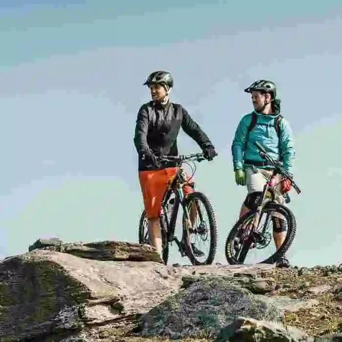
CYCLING
From 400 SEKTO KEEP IN MIND:
To cycle in the mountains is allowed by the Swedish right of public access, but just as for hikers and others travelling in nature, you’re not allowed to damage the nature. The Swedish right of public (allemansrätten) does not give right to use bikes with an engine in the mountains.
Stick to tracks and trails. For example, is it not allowed to cycle downhill in mires. The Swedish Environmental Protection Agency strictly recommend to stick to the trails. The flora in the mountains are very sensitive. For example it takes 50 years for crowberry shrubs to recover.
Municipalities in Sweden are allowed to make local restrictions. Before you head out, make sure to find out if there are any local restrictions you need to abide by.
Also keep in mind that the help can be far away, and cell phones may not always have reception. Don’t take any unnecessary risks and always carry a first-aid kit.
A SELECTION OF TRAILS IN THE AREA
RALLARVÄGEN TOWARDS RIKSGRÄNSEN (THE NAVY ROAD)
15 vertical meters and 0 – 30 km. Green
The old navy road stretch along the railway west from Björkliden. You can decide for yourself how far you want to cycle before turning back home. If it is the first time you try mountain biking, the trail up until the old navy cemetery is the best stretch you can find. It is about 4 km with some ups and downs, a quite broad trail and some unevenness without being too much. The rail reaches all the way to Riksgränsen but the stretch between Björkliden and the lake Baktájarvi is the most frequently travelled. After Baktájarvi, the trail narrows before opening up at Låkta anhalt (about 12 km). From that point until Riksgränsen, the trail gets wider again.
RALLARVÄGEN TOWARDS ABISKO (THE NAVY ROAD)
10 vertical meters and 0 – 6,5 km. Green
If you want to take the next step in mountain biking without cycling uphill, the Navy Road towards Abisko can be a good alternative. The trail doesn’t contain many vertical meters but the challenge is about cycling on foodbridge. It’s about staying on track and trust that the bike is going the way to steer it. To cycle on a footbridge is not as hard as you would imagine. When you cycle, you steer the bike straight with small margins. Watch out for wide space between the planks or if the footbridge is very wet after a downpour. There’s less footbridge the closer to Abisko you get, and while at the tourist station, you can congratulate yourself with a fika.
KUNGSLEDEN TO ABISKOJAURE (THE KING’S TRAIL)
20 vertical meters and 0 – 20 km one way, Green/Blue
If you have access to a car or would like to extend your cycling adventure in Abisko, you can start at Abisko tourist station and head out on the King’s Trail south towards the Abiskojaure cabin. The King’s Trail is relatively rocky and can be experienced as a bit more difficult to cycle, despite it being flat. However, there’s a well-trodden trail. It is allowed to cycle in the state park but keep in mind to stick to the trail so you don’t do damage to the nature. If the nature becomes too damaged, bikes may be prohibited in the state park. Also keep in mind that electrical bikes are seen as motor vehicles according to the Environmental Protection Agency and are prohibited.
KRATERSJÖN
30 vertical meters and 5 km roundtrip, Blue/(Red)
If you are craving for something a bit more technical then the trail to the lake of Kratesjön might be it. To cycle here takes a bit more experience, good balance and determination and willingness to walk a few steps with your bike. From Björkliden, we recommend you to follow the start of the trail towards Låktatjåkko Mountain Lodge but when the climbing starts, turn towards the midnight sun sport (yellow marks on rocks) and from there, follow the trails towards the lake. Upon arrival at the lake, it might be nice with a snack and a swim before turning back home. On the way home you will follow the red crosses and the lower path. From the lake it’s possible to go downhill to the navy cemetery and to follow the navy road home. However, to do that we recommend that you are an experienced downhill biker or prepared to lead you bike down since the trail between the lake and the cemetery is partly very steep downhill.
BJÖRNFJELL TO ROMBAKKSBOTN
15 km one way, Green/(Blue)
If you are in the mood for a full day trip and a fantastic scenery, this is the tour for you! You start just on the other side of the Norwegian border at the train station Björnfjell, by the E10 highway marked by a train sign. You follow the Norwegian part of the navy road that starts by the station. It is a downhill trail going all the way down the seaside and the Rombaksfjord. The trail is generally wide and uncomplicated, but with parts that are more rocky than others. It stretches along the railway, which has been appointed one of the most beautiful scenery in the world with the mountains and the ocean as backdrop. The trail itself is quite easy to ride, it is all about keeping the balance when you reach some of the parts where you have steep verges at your side. When you reach the ocean floor there are two options; either you turn the bike around and cycle back up, or you can take the ferry to Narvik that normally departs two days a week. There is a bus departing from Narvik bus station back to Bjorkliden and the buss is a short ride from the harbor in Narvik.
LÅKTATJÅKKO MOUNTAIN LODGE ANTI-CLOCKWISE
800 vertical meters and appx 18 km, Blue/(Red)
You can reach Låktatjåkko Mountain Lodge from two directions, either up from Björkliden or from the other direction, coming from the mountain pass, starting at the highway E10 and Låkta Anhalt. If you can, we recommend that you start from Låkta anhalt and cycle up to Låktatjåkko and from there, cycle down towards Björkliden. When driving to the starting point, after having passed the Låktajokken (Låktatjåkko river), keep an eye out for two parking lots next to the highway and a small blue sign that marks the trail up to Låkta anhalt (the train station). You follow the trail starting by the blue sign and will soon reach the railway. You need to cross the railway but be careful, the trains drive by without warning. Carry your bike over the railway!
The trail continues uphill behind the station house. Follow the trail and you will reach a crossroad after approximately 200 meters. There you take left (east) and follow the path up to Låkta. This trail was created when the mountain station was built. You follow the trail and not the red crosses. Your legs will most likely burn on the way up to the mountain lodge since it’s about an 800 meters vertical climb. Despite the burning muscles, try to keep your eyes up and enjoy the magnificent scenery.
You will reach the mountain lodge after about 8 km. Låktatjåkko Mountain Lodge is known for its waffles. Why not taking a break and try one with cloudberries and cream? The trail home to Björkliden is slightly longer but with a new scenery and a bit more varied terrain. It offers an amazing scenery over lake Torneträsk and the mountains on the other side. There are two trails downhill, the summer path (Sommarleden) and the guides trail (färdledarvägen). The staff at the lodge will gladly tell you which one of the paths that has the best conditions on that day. Generally, the summer path is more wet but les rocky, while the guides trail is dryer but with more rocks to cycle on and a bit steeper. Both trails can partly be covered with snow patches but in summertime the patches are often so hard that you can cycle on them.